Accident Prevention ProgramDead Reckoning NavigationAre you ready to fall back to the lost art of compass and clock if your electronic aids fail? It is generally agreed that the compass is a pilot's primary navigation tool. But when it comes to specifying the second most valuable such device in the cockpit, there is often some difference of opinion. New pilots generally favor the VOR receiver. But those with more experience vote for the clock. After all, when a fuse blows or the left-right needle behaves like a metronome gone berserk, a pilot must resort to basics. The reliable compass and clock beomes his primary weapons in a battle of wits against the elements. The compass indicates where he's going and the clock tells him how far. Without either of these allies, a pilot can get lost, very fast, especially when above clouds or when over terrain where checkpoints are confusingly few and far apart. Compass-and-clock, or dead-reckoning navigation, however, is slowly becoming a lost art as increasingly more reliance is placed on electronic guidance. Although no one can deny that VOR navigation has simplified cockpit workloads, pilots must avoid becoming too complacent. Some, for example, don't keep track of their forward progress while navigating along a radial. They simply wait for the TO-FROM flag to drop, which may provide the first positive fix since passing the previous station. But shouldn't a pilot always know his position relative to the nearest airport? Dead reckoning, or DR navigation, is a relatively painless procedure that can and should be combined with radio navigation so that a pilot is aware of his approximate position at all times. According to popular definition, dead reckoning is short for "deduced reckoning" or, as the old-timers used to say "you're dead if you don't reckon right." In truth, however, the term originated with maritime navigation and refers to "reckoning or reasoning (one's position) relative to something stationary or dead in the water." Simply stated, DR navigation is a method of precluding en route progress based on the direction of flight and the estimated ground speed since the last known position. Unfortunately, the mere mention of DR often makes a pilot uncomfortable with memories of FAA written examinations, wind triangles, and E-6B "confusers." But DR doesn't have to be laborious. Consider, for example, Jack Chrysler, an ATP who flies his Aerostar 601 all over North and South America. Chrysler has so simplified his dead reckoning procedures that he feels they are not only fun to use, but frequently result in reduced flight time because he is not confined to the often dog-legged dictates of Victor airways. Also, he claims to be more relaxed holding a constant heading than reacting to the semaphore-like movements of a VOR needle. Prior to a VFR flight, Chrysler simply uses a yard stick and a VFR planning chart (JN charts outside the United States) to plot a direct course between the departure and destination airports (assuming that intervening terrain and other restrictions do not pose a threat to safety or legality). He then uses the forecasted winds aloft together with Tables 1 and 2 to determine the true heading and ground speed. Assume, for example, that the measured true course is 040 degrees and the winds aloft are expected to be from O1O degrees at 40 knots. In other words, the wind will be blowing from 30 degrees to the left of the nose. Using Table 1, he determines that this is equivalent to a 35-knot headwind component and a 20-knot, left crosswind component. Since the planned true airspeed is 220 knots, he expects the en route ground speed to be 185 knots (220 - 35 = 185). (Table 1) Table 1
TABLE 1 PROVIDES HEADWIND/TAILWIND AND CROSSWIND COMPONENTS for various wind velocities. The upper-left figure in each square represents a headwind or tailwind component depending on whether the wind is coming from ahead or behind; the lower-right figure represents a left or right crosswind component (depending also on wind direction). Next he consults Table 2 and determines that a 20-knot, left crosswind component combines with 220 knots of airspeed to require a 5 degree (left) wind correction angle. The true heading for the proposed flight, therefore, is 040 degrees less 5 degrees, or 035 degrees. End of problem . . . without having to plot a wind triangle.
TABLE 2 PROVIDES THE CRAB ANGLE necessary to compensate for a given crosswind component when flying at a given true airspeed and is valid for knots or mph. CAUTION: crabbing, or turning into the wind, results in some loss of groundspeed, but this can be ingnored when the crab angle is less than 10 degrees. When the crab angle exceeds 10 degrees, use Table 3 to determine loss of groundspeed solely due to crabbing.
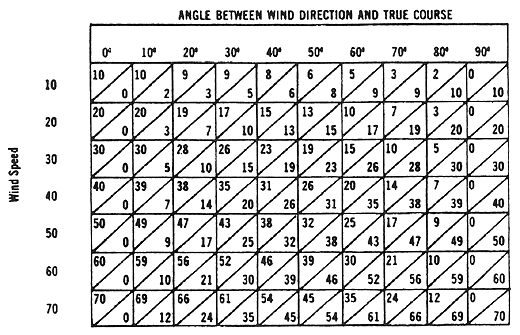
TABLE 3 PROVIDES GROUNDSPEED LOSS due to crabbing into the wind when flying at a given true airspeed and is valid for knots or mph. (Refer to CAUTION note under Table 2.) If more than one wind condition is to be encountered en route, they may be arithmetically averaged with reasonable accuracy if wind directions don't vary by more than 90 degrees and wind speeds are within 15 knots of each other. For example, assume that the winds aloft for each of three flight segments along the direct route are forecast to be 080 degrees/15kt, 1OO degrees/30kt and 150 degrees/30kt. The average wind direction is (O8O + lOO + 150) divided by 3 = 11O degrees. Similiary, the average wind speed is 25 knots. This technique should not be used, however, when maximum accuracy is required (such as on a long, overwater flight). En route, Chrysler keeps track af his progress visually or uses elapsed time and estimated ground speed to plot a "DR position." Often, he doesn't turn on the dval VOR receivers until within range of the destination . . . if at all. (When necessary, he applies a mid-course correction to compensate for an errant wind forecast.) Dead reckoning works and it's reasonably accurate. Ask the man who pioneered the 2,000-mile, New-foundland-to-Ireland route in 1927 as well as the thousands of pilots who have flown in his wake . . . with little more than a compass and a clock. (Lindberg was luckier than is generally realized, however. According to lohn P. V. Heinmuller, one of the official NAA observers for the New York-to-Paris flight, a freak wind condition existed over the North Atlantic on May 20-22, 1927. The pressure patterns were arranged in such a way that the net drift acting upon the Spirit of St. Louis was zero, the first time this had ever been recorded by weather experts.) If an aircraft maintains its predicted ground speed and track, then a positive fix obtained at any time during the flight will agree with the aircraft position as determined by DR methods. More likely, however, an actval fix (using radio or pilotage/or both) will disagree with the DR position. Usually, this is because one or more variables have been appraised incorrectly. In other words, there is an element of uncertainty surrovnding every fix determined purely by dead reckoning. A rule of thumb states that 90% of the time the maximum dead reckoning error (per hour of flight) is 20 miles plus 1% of the estimated distance flown during that hour.
Figure 1, for example, shows where the pilot of a 150-knot aircraft has computed his position to be at the end of one hour. The radius of the circle of uncertainty is equal, therefore, to 20 nautical miles (nm) +1% of which equals 21.5 nm. In other words, there is a 90% probability that the pilot is actually within 21.5 nm of where he thinks he is. It also can be shown that 50% of the time the aircraft is located within a circle with only one-third the radius of the larger circle. In this case, the pilot has a fifty-fifty chance of being within 7.2 nm of the DR position. One way to reduce the size of the circle of uncertainty is to make sure the compass deviation card is reasonably accurate. The FAA doesn't require a periodic compass swing, but pilots would be wise to perform this check at least annually. Deviation errors can change significantly over a period of time. Also, make it a habit to glance at the compass whenever lining up on a runway of known magnetic direction. Remember, however, that the runway number usually represents the magnetic direction rounded off to the nearest 10 degrees. Some runway numbers disagree by more than 10 degrees with the actual magnetic directions. Tucson's Runway 11L, for example, has a magnetic direction of 122 degrees. None of this should be interpreted as an argument against VOR navigation in favor of DR. But it is nice to know that there is an alternate, reliable way to get from one place to another when VOR is unavailable and pilotage is difficult. All that is required is some common sense reasoning. The idea is to be aware of the wind and its effects and to maintain a running score of flight progress either on a flight log or by making marks on the chart and labeling each position (estimated or actual) with the time of passage. Not only can DR be used to compute progress along a radial, it can also be used in conjunction with VOR to arrive at a "running fix." Consider the pilot flying from A to B in Figure 2. He's not necessarily lost, but it has been a while since the last positive fix. He's also having trouble correlating contour lines on the chart with those on the ground.
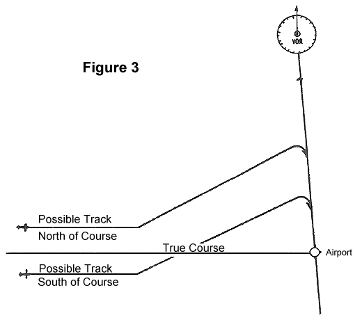
At 1 p.m., the aircraft crosses a railroad track, an excellent line of position (LOP). But one LOP does not establish a fix. Eighteen minutes later, the pilot is within range of a VOR station and determines that he is on the 230 degree radial. Again, the pilot has a single LOP, not enough to establish position . . . or is it? A fix can be obtained by advancing the 1 p.m. LOP (the railroad tracks) toward the second LOP (the radial). This is accomplished by first estimating the distance flown since crossing the first LOP. Assume, for example, that the estimated ground speed of the aircraft in Figure 2 is 150 knots. In 18 minutes, therefore, the distance flown is about 45 nm. The first LOP is then advanced (parallel to itself) 45 nm in the direction of the estimated track being flown. The point where the advanced LOP intersects the VOR radial (the second LOP) is the fix for 1:18 p.m. and shows the aircraft to be north of course. A running fix can be obtained using any two LOPs as long as they cross at a reasonably oblique angle. They may be highways, rivers, or even a pair of radials crossed at different times. Another combination of DR and VOR navigation is called the "single-line approach." This technique can be life saving and is illustrated in Figure 3. A pilot is endeavoring to fly a true course of 090 degrees toward the Chutzpah Airport which is on the 170 degree radial of a VORTAC (far to the north of course). The pilot estimated arriving over the airport at 2:55 p.m. Unfortunately, he has been unable to obtain a reliable and recent fix and isn't sure that he's on course. So, what should he do if, upon intercepting the 170 degree radial, the airport cannot be found? Should he fly north or south along the radial to find the destination? Since he is running low on fuel, he can't afford to turn in the wrong direction. Dead reckoning (or common sense) navigation offers a logical solution. About 45 minutes prior to ETA, the pilot shovld make a sufficiently large turn and purposefully intercept the radial north (or south) of the airport.
When the 170 degree radial is finally intercepted, the pilot knows with reasonable confidence which way to turn. By turning off covrse intentionally, he eliminates the likelihood of turning, searching, and wasting fuel in the wrong direction. This procedure is also known as the "landfall intercept" and doesn't require that the destination be on a VOR rodial. The airport could be situated on a river, shoreline, highway, railroad, or anything else that is easily identifiable and is approximately perpendiculor to the true course. Nor does the single-line approach have to be reserved for locating a destination. It can be used with equal effectiveness to find a needed en route checkpoint. DR teaches another valuable lesson, how to avoid a midair collision. In pre-radar days, one of the techniques a fighter aircraft could use to intercept another airplane required that the two aircraft lie on a "line of constant bearing." In other words the direction of one aircraft from the other must remain constant (as long as each aircraft maintains a constant heading and airspeed). The same is true of two aircraft on collision courses. Visually, this means that if an aircraft remains fixed at a specific point on your windshield and he is at your altitude, you may expect an encounter of the wrong kind. To avoid such an unpleasantry, change heading so that the "bogie" appears to move across your windshield. When this happens, the two aircraft are not maintaining a constant bearing from one another and an "intercept" is impossible. DR offers much to the pilot willing to expend a little extra effort. And it won't take him long to learn that DR really stands for Darned Reliable. He'll also learn that the big three in navigation aren't Collins, King, and Narco; they're Rate, Time, and Distance. (END OF DOCUMENT FAA-P-8740-22 AFS-800-0279) |
||||||||||||||||||||||||||||||||||||||||||||||||||||||||||||||||||||||||||||||||||||||||||||||||||||||||||||||||||||||||||||||||||||||||||||||||||||||||||||||||||||||||||||||||||||||||||||||||||||||||||||||||||||||||||||||||||||||||