|
For Pilots and Flight Operations Personnel PART I. WHAT YOU SHOULD KNOW ABOUT WEATHER
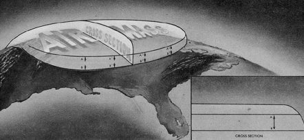
Why is weather today clear and cold over Oklahoma while it is warm and moist over Alabama? What caused the line of thunderstorms that you circumnavigated over eastern Arkansas? Air masses and fronts provide the answer. You can better plan the safety and economy of flight when you can evaluate the expected effects of air masses and fronts. This chapter explains air masses and fronts and relates them to weather and flight planning.
Just as an air mass took on the properties of its source region, it tends to take on properties of the underlying surface when it moves away from its source region, thus becoming modified. The degree of modification depends on the speed with which the air mass moves, the nature of the region over which it moves, and the temperature difference between the new surface and the air mass. Some ways air masses are modified are: (1) warming from below, (2) cooling from below, (3) addition of water vapor, and (4) subtraction of water vapor:
STABILITY Stability of an air mass determines its typical weather characteristics. When one type of air mass overlies another, conditions change with height. Characteristics typical of an unstable and a stable air mass are as follows: Unstable Air Stable Air Cumuliform clouds Stratiform clouds and fog Showery precipitation Continuous precipitation Rough air (turbulence) Smooth air Good visibility, Fair to poor visibility in haze and smoke except in blowing obstructions
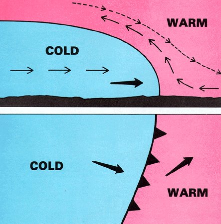
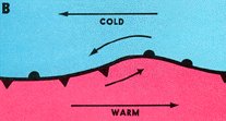
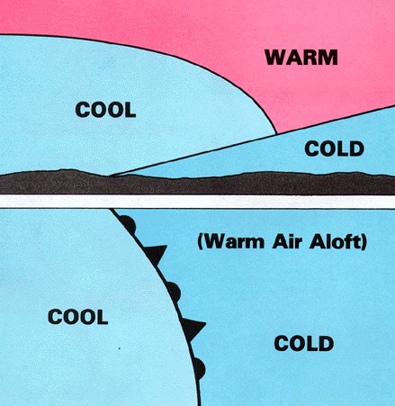
When you pass through a front, the change from the properties of one air mass to those of the other is sometimes quite abrupt. Abrupt changes indicate a narrow frontal zone. At other times, the change of properties is very gradual indicating a broad and diffuse frontal zone. Temperature Temperature is one of the most easily recognized discontinuities across a front. At the surface, the passage of a front usually causes noticeable temperature change. When flying through a front, you note a significant change in temperature, especially at low altitudes. Remember that the temperature change, even when gradual, is faster and more pronounced than a change during a flight wholly within one air mass. Thus, for safety, obtain a new altimeter setting after flying through a front. Chapter 3 discussed the effect of a temperature change on the aircraft altimeter. Dew Point As you learned in Chapter 5, dew point temperature is a measure of the amount of water vapor in the air. Temperature-dew point spread is a measure of the degree of saturation. Dew point and temperature-dew point spread usually differ across a front. The difference helps identify the front and may give a clue to differences of cloudiness and/or fog. Wind Wind always changes across a front. Wind discontinuity may be in direction, in speed, or in both. Be alert for a wind shift when flying in the vicinity of a frontal surface; if the wind shift catches you unaware it can get you off course or even lost in a short time. The relatively sudden change in wind also creates wind shear, and you will study its significance in the next chapter, "Turbulence." Pressure A front lies in a pressure trough, and pressure generally is higher in the cold air. Thus, when you cross a front directly into colder air, pressure usually rises abruptly. When you approach a front toward warm air, pressure generally falls until you cross the front and then remains steady or falls slightly in the warm air. However, pressure patterns vary widely across fronts, and your course may not be directly across a front. The important thing to remember is that when crossing a front, you will encounter a difference in the rate of pressure change; be especially alert in keeping your altimeter setting current. TYPES OF FRONTS The three principal types of fronts are the cold front, the warm front, and the stationary front. Cold Front The leading edge of an advancing cold air mass is a cold front. At the surface, cold air is overtaking and replacing warmer air. Cold fronts move at about the speed of the wind component perpendicular to the front just above the frictional layer. Figure 59 shows the vertical cross section of a cold front and the symbol depicting it on a surface weather chart. A shallow cold air mass or a slow moving cold front may have a frontal slope more like a warm front shown in figure 60.
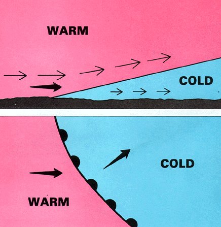
Figure 60. Cross section of a warm front (top) with the weather map symbol (bottom). The symbol is a line with rounded barbs pointing in the direction of movement. If a map is in color, a red line represents the warm front. Slope of a warm front generally is more shallow than slope of a cold front. Movement of a warm front shown by the heavy black arrow is slower than the wind in the warm air represented by the light solid arrows. The warm air gradually erodes the cold air.
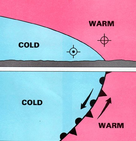
The edge of an advancing warm air mass is a warm front - warmer air is overtaking and replacing colder air. Since the cold air is denser than the warm air, the cold air hugs the ground. The warm air slides up and over the cold air and lacks direct push on the cold air. Thus, the cold air is slow to retreat in advance of the warm air. This slowness of the cold air to retreat produces a frontal slope that is more gradual than the cold frontal slope as shown in figure 60. Consequently, warm fronts on the surface are seldom as well marked as cold fronts, and they usually move about half as fast, when the general wind flow is the same in each case. Stationary Fronts When neither air mass is replacing the other, the front is stationary. Figure 61 shows a cross section of a stationary front and its symbol on a surface chart. The opposing forces exerted by adjacent air masses of different densities are such that the frontal surface between them shows little or no movement. In such cases, the surface winds tend to blow parallel to the frontal zone. Slope of a stationary front is normally shallow, although it may be steep depending on wind distribution and density difference.
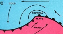
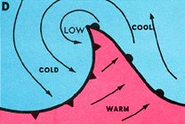
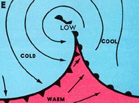
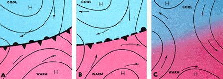
Frontal waves and cyclones (areas of low pressure) usually form on slow moving cold fronts or on stationary fronts. The life cycle and movement of a cyclone is dictated to a great extent by the upper wind flow. In the initial condition of frontal wave development in figure 62, the winds on both sides of the front are blowing parallel to the front (A). Small disturbances then may start a wavelike bend in the front (B).
Since fronts are boundaries between air masses of different properties, fronts are not associated with lows lying solely in a homogeneous air mass. Nonfrontal lows are infrequent east of the Rocky Mountains in mid-latitudes but do occur occasionally during the warmer months. Small nonfrontal lows over the western mountains are common as is the semi-stationary thermal low in extreme Southwestern United States. Tropical lows are also nonfrontal. As adjacent air masses modify and as temperature and pressure differences equalize across a front, the front dissipates. This process, frontolysis, is illustrated in figure 65. Frontogenesis is the generation of a front. It occurs when a relatively sharp zone of transition develops over an area between two air masses which have densities gradually becoming more and more in contrast with each other. The necessary wind flow pattern develops at the same time. Figure 66 shows an example of frontogenesis with the symbol.
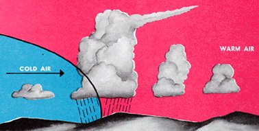
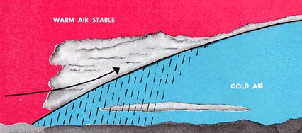
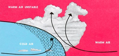
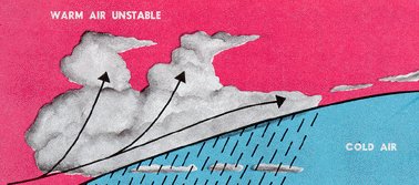
In fronts, flying weather varies from virtually clear skies to extreme hazards including hail, turbulence, icing, low clouds, and poor visibility. Weather occurring with a front depends on (1) the amount of moisture available, (2) the degree of stability of the air that is forced upward, (3) the slope of the front, (4) the speed of frontal movement, and (5) the upper wind flow. Sufficient moisture must be available for clouds to form, or there will be no clouds. As an inactive front comes into an area of moisture, clouds and precipitation may develop rapidly. A good example of this is a cold front moving eastward from the dry slopes of the Rocky Mountains into a tongue of moist air from the Gulf of Mexico over the Plains States. Thunderstorms may build rapidly and catch a pilot unaware. The degree of stability of the lifted air determines whether cloudiness will be predominately stratiform or cumuliform. If the warm air overriding the front is stable, stratiform clouds develop. If the warm air is unstable, cumuliform clouds develop. Precipitation from stratiform clouds is usually steady as illustrated in figure 67 and there is little or no turbulence. Precipitation from cumuliform clouds is of a shower type as in figure 68, and the clouds are turbulent.
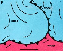
Figure 68. A cold front underrunning warm, moist, unstable air. Clouds are cumuliform with possible showers or thunderstorms near the surface position of the front. Convective clouds often develop in the warm air ahead of the front. The warm, wet ground behind the front generates low-level convection and fair weather cumulus in the cold air.
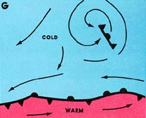
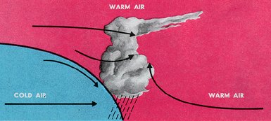
Figure 71. A warm front with overrunning warm, moist, unstable air. Weather, clouds, and hazards are similar to those described in figure 70 except that they generally are more widespread.
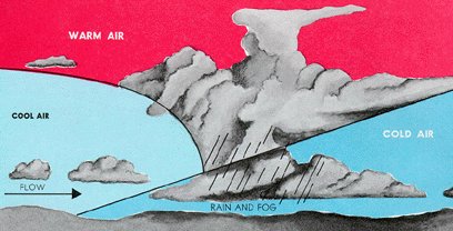
Figure 74. A cold front occlusion lifting warm, moist, stable air. Associated weather encompasses types of weather associated with both warm and cold fronts when air is moist and stable.
The upper wind flow dictates to a great extent the amount of cloudiness and rain accompanying a frontal system as well as movement of the front itself. Remember in chapter 4 we said that systems tend to move with the upper winds. When winds aloft blow across a front, it tends to move with the wind. When winds aloft parallel a front, the front moves slowly if at all. A deep, slow moving trough aloft forms extensive cloudiness and precipitation, while a rapid moving minor trough more often restricts weather to a rather narrow band. However, the latter often breeds severe, fast moving, turbulent spring weather. INSTABILITY LINE An instability line is a narrow, nonfrontal line or band of convective activity. If the activity is fully developed thunderstorms, figure 75, the line is a squall line (chapter 11, "Thunderstorms"). Instability lines form in moist unstable air. An instability line may develop far from any front. More often, it develops ahead of a cold front, and sometimes a series of these lines move out ahead of the front. A favored location for instability lines which frequently erupt into severe thunderstorms is a dew point front or dry line.
During a considerable part of the year, dew point fronts are common in Western Texas and New Mexico northward over the Plains States. Moist air flowing north from the Gulf of Mexico abuts the dryer and therefore slightly denser air flowing from the southwest. Except for moisture differences, there is seldom any significant air mass contrast across this "Front"; and therefore, it is commonly called a "dry line." Nighttime and early morning fog and low level clouds often prevail on the moist side of the line while generally clear skies mark the dry side. In spring and early summer over Texas, Oklahoma, and Kansas, and for some distance eastward, the dry line is a favored spawning area for squall lines and tornadoes.
Frontal weather may change rapidly. For example, there may be only cloudiness associated with a cold front over northern Illinois during the morning but with a strong squall line forecast by afternoon. Skies may be partly cloudy during the afternoon over Atlanta in advance of a warm front, but by sunset drizzle and dense fog are forecast. A cold front in Kansas is producing turbulent thunderstorms, but by midnight the upper flow is expected to dissipate the thunderstorms and weaken the front. A Pacific front is approaching Seattle and is expected to produce heavy rain by midnight. A mental picture of what is happening and what is forecast should greatly aid you in avoiding adverse weather conditions. If unexpected adverse weather develops en route, your mental picture aids you in planning the best diversion. If possible, always obtain a good preflight weather briefing. We suggest you again look at figures 67 through 75 and review weather conditions associated with different types of fronts and stability conditions. These are only a few of many possibilities, but they should give some help during preflight planning or inflight diversion.
|