|
For Pilots and Flight Operations Personnel PART I. WHAT YOU SHOULD KNOW ABOUT WEATHER
Everyone who flies encounters turbulence at some time or other. A turbulent atmosphere is one in which air currents vary greatly over short distances. These currents range from rather mild eddies to strong currents of relatively large dimensions. As an aircraft moves through these currents, it undergoes changing accelerations which jostle it from its smooth flight path. This jostling is turbulence. Turbulence ranges from bumpiness which can annoy crew and passengers to severe jolts which can structurally damage the aircraft or injure its passengers. Aircraft reaction to turbulence varies with the difference in windspeed in adjacent currents, size of the aircraft, wing loading, airspeed, and aircraft attitude. When an aircraft travels rapidly from one current to another, it undergoes abrupt changes in acceleration. Obviously, if the aircraft moved more slowly, the changes in acceleration would be more gradual. The first rule in flying turbulence is to reduce airspeed. Your aircraft manual most likely lists recommended airspeed for penetrating turbulence. Knowing where to expect turbulence helps a pilot avoid or minimize turbulence discomfort and hazards. The main causes of turbulence are (1) convective currents, (2) obstructions to wind flow, and (3) wind shear. Turbulence also occurs in the wake of moving aircraft whenever the airfoils exert lift - wake turbulence. Any combination of causes may occur at one time.
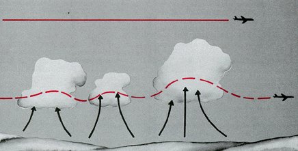
Convective currents are most active on warm summer afternoons when winds are light. Heated air at the surface creates a shallow, unstable layer, and the warm air is forced upward. Convection increases in strength and to greater heights as surface heating increases. Barren surfaces such as sandy or rocky wastelands and plowed fields become hotter than open water or ground covered by vegetation. Thus, air at and near the surface heats unevenly. Because of uneven heating, the strength of convective currents can vary considerably within short distances. When cold air moves over a warm surface, it becomes unstable in lower levels. Convective currents extend several thousand feet above the surface resulting in rough, choppy turbulence when flying in the cold air. This condition often occurs in any season after the passage of a cold front. Figure 76 illustrates the effect of low level convective turbulence on aircraft approaching to land. Turbulence on approach can cause abrupt changes in airspeed and may even result in a stall at a dangerously low altitude. To prevent the danger, increase airspeed slightly over normal approach speed. This procedure may appear to conflict with the rule of reducing airspeed for turbulence penetration; but remember, the approach speed for your aircraft is well below the recommended turbulence penetration speed.
The pilot should also know that when air is too dry for cumulus to form, convective currents still can be active. He has little indication of their presence until he encounters turbulence.
Mechanical turbulence can also cause cloudiness near the top of the mechanically disturbed layer. However, the type of cloudiness tells you whether it is from mechanical or convective mixing. Mechanical mixing produces stratocumulus clouds in rows or bands, while convective clouds form a random pattern. The cloud rows developed by mechanical mixing may be parallel to or perpendicular to the wind depending on meteorological factors which we do not discuss here. The airport area is especially vulnerable to mechanical turbulence which invariably causes gusty surface winds. When an aircraft is in a low level approach or a climb, airspeed fluctuates in the gusts, and the aircraft may even stall. During extremely gusty conditions, maintain a margin of airspeed above normal approach or climb speed to allow for changes in airspeed. When landing with a gusty crosswind as illustrated in figure 79, be alert for mechanical turbulence and control problems caused by airport structures upwind. Surface gusts also create taxi problems.
When flying over rolling hills, you may experience mechanical turbulence. Generally, such turbulence is not hazardous, but it may be annoying or uncomfortable. A climb to higher altitude should reduce the turbulence. When flying over rugged hills or mountains, however, you may have some real turbulence problems. Again, we cannot discuss mechanical turbulence without considering wind speed and stability. When wind speed across mountains exceeds about 40 knots, you can anticipate turbulence. Where and to what extent depends largely on stability. If the air crossing the mountains is unstable, turbulence on the windward side is almost certain. If sufficient moisture is present, convective clouds form intensifying the turbulence. Convective clouds over a mountain or along a ridge are a sure sign of unstable air and turbulence on the windward side and over the mountain crest. As the unstable air crosses the barrier, it spills down the leeward slope often as a violent downdraft. Sometimes the downward speed exceeds the maximum climb rate for your aircraft and may drive the craft into the mountainside as shown in figure 80. In the process of crossing the mountains, mixing reduces the instability to some extent. Therefore, hazardous turbulence in unstable air generally does not extend a great distance downwind from the barrier.
When stable air crosses a mountain barrier, the turbulent situation is somewhat reversed. Air flowing up the windward side is relatively smooth. Wind flow across the barrier is laminar - that is, it tends to flow in layers. The barrier may set up waves in these layers much as waves develop on a disturbed water surface. The waves remain nearly stationary while the wind blows rapidly through them. The wave pattern, diagrammed in figure 81, is a " standing" or "mountain" wave, so named because it remains essentially stationary and is associated with the mountain. The wave pattern may extend 100 miles or more downwind from the barrier. Wave crests extend well above the highest mountains, sometimes into the lower stratosphere. Under each wave crest is a rotary circulation also diagrammed in figure 81. The "rotor" forms below the elevation of the mountain peaks. Turbulence can be violent in the overturning rotor. Updrafts and down drafts in the waves can also create violent turbulence.
MOUNTAIN FLYING When planning a flight over mountainous terrain, gather as much preflight information as possible on cloud reports, wind direction, wind speed, and stability of air. Satellites often help locate mountain waves. Figures 84 and 85 are photographs of mountain wave clouds taken from spacecraft. Adequate information may not always be available, so remain alert for signposts in the sky. What should you look for both during preflight planning and during your inflight observations?
Figure 85. Satellite photograph of a mountain wave and the surface weather map for approximately the same time. A single mountain in the Aleutian chain generates the wave. Note how it spirals downwind from the source. Without the satellite, the turbulent wave would have gone undetected unless some aircraft had flown into it.
When approaching mountains from the leeward side during strong winds, begin your climb well away from the mountains - 100 miles in a mountain wave and 30 to 50 miles otherwise. Climb to an altitude 3,000 to 5,000 feet above mountain tops before attempting to cross. The best procedure is to approach a ridge at a 45 degree angle to enable a rapid retreat to calmer air. If unable to make good on your first attempt and you have higher altitude capabilities, you may back off and make another attempt at higher altitude. Sometimes you may have to choose between turning back or detouring the area. Flying mountain passes and valleys is not a safe procedure during high winds. The mountains funnel the wind into passes and valleys thus increasing wind speed and intensifying turbulence. If winds at mountain top level are strong, go high, or go around. Surface wind may be relatively calm in a valley surrounded by mountains when wind aloft is strong. If taking off in the valley, climb above mountain top level before leaving the valley. Maintain lateral clearance from the mountains sufficient to allow recovery if caught in a downdraft.
WIND SHEAR WITH A LOW LEVEL TEMPERATURE INVERSION A temperature inversion forms near the surface on a clear night with calm or light surface wind as discussed in chapter 2. Wind just above the inversion may be relatively strong. As illustrated in figure 86, a wind shear zone develops between the calm and the stronger winds above. Eddies in the shear zone cause airspeed fluctuations as an aircraft climbs or descends through the inversion. An aircraft most likely is either climbing from takeoff or approaching to land when passing through the inversion; therefore, airspeed is slow - only a few knots greater than stall speed. The fluctuation in airspeed can induce a stall precariously close to the ground.
When taking off or landing in calm wind under clear skies within a few hours before or after sunrise, be prepared for a temperature inversion near the ground. You can be relatively certain of a shear zone in the inversion if you know the wind at 2,000 to 4,000 feet is 25 knots or more. Allow a margin of airspeed above normal climb or approach speed to alleviate danger of stall in event of turbulence or sudden change in wind velocity. WIND SHEAR IN A FRONTAL ZONE As you have learned in chapter 8, a front can contain many hazards. However, a front can be between two dry stable air masses and can be devoid of clouds. Even so, wind changes abruptly in the frontal zone and can induce wind shear turbulence. The degree of turbulence depends on the magnitude of the wind shear. When turbulence is expected in a frontal zone, follow turbulence penetration procedures recommended in your aircraft manual.
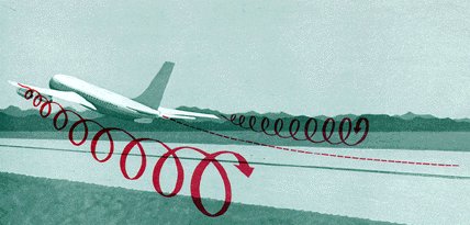
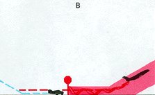
The turbulence persists several minutes and may linger after the aircraft is out of sight. At controlled airports, the controller generally warns pilots in the vicinity of possible wake turbulence. When left to your own resources, you could use a few pointers. Most jets when taking off lift the nose wheel about midpoint in the takeoff roll; therefore, vortices begin about the middle of the takeoff roll. Vortices behind propeller aircraft begin only a short distance behind liftoff. Following a landing of either type of aircraft, vortices end at about the point where the nose wheel touches down. Avoid flying through these vortices. More specifically, when using the same runway as a heavier aircraft: (1) if landing behind another aircraft, keep your approach above his approach and keep your touchdown beyond the point where his nose wheel touched the runway (figure 88 (A));
(3) if departing behind another departing aircraft, takeoff only if you can become airborne before reaching the midpoint of his takeoff roll and only if you can climb fast enough to stay above his flight path (figure 88 (c)); and
(4) if departing behind a landing aircraft, don't unless you can taxi onto the runway beyond the point at which his nose wheel touched down and have sufficient runway left for safe takeoff (figure 88 (D)).
If parallel runways are available and the heavier aircraft takes off with a crosswind on the downwind runway, you may safely use the upwind runway. Never land or take off downwind from the heavier aircraft. When using a runway crossing his runway, you may safely use the upwind portion of your runway. You may cross behind a departing aircraft behind the midpoint of his takeoff roll. You may cross ahead of a landing aircraft ahead of the point at which his nose wheel touches down. If none of these procedures is possible, wait 5 minutes or so for the vortices to dissipate or to blow off the runway. The foregoing procedures are elementary. The problem of wake turbulence is more operational than meteorological. The FAA issues periodic advisory circulars of operational problems. If you plan to operate out of airports used routinely by air carriers, we highly recommend you read the latest advisory circulars on wake turbulence. Titles of these circulars are listed in the FAA "Advisory Circular Checklist and Status of Regulations."
Generally, when a pilot receives a forecast, he plans his flight to avoid areas of most probable turbulence. Yet the best laid plans can go astray and he may encounter turbulence. Since no instruments are currently available for directly observing turbulence, the man on the ground can only confirm its existence or absence via pilot reports. HELP YOUR FELLOW PILOT AND THE WEATHER SERVICE - SEND PILOT REPORTS. To make reports and forecasts meaningful, turbulence is classified into intensities based on the effects it has on the aircraft and passengers. Section 16 {Should be Section 14 - Ed.} of AVIATION WEATHER SERVICES (AC 00-45) lists and describes these intensities. Use this guide in reporting your turbulence encounters.
|