|
For Pilots and Flight Operations Personnel PART I. WHAT YOU SHOULD KNOW ABOUT WEATHER
Aircraft icing is one of the major weather hazards to aviation. Icing is a cumulative hazard. It reduces aircraft efficiency by increasing weight, reducing lift, decreasing thrust, and increasing drag. As shown in figure 89, each effect tends to either slow the aircraft or force it downward. Icing also seriously impairs aircraft engine performance. Other icing effects include false indications on flight instruments, loss of radio communications, and loss of operation of control surfaces, brakes, and landing gear.
Supercooled water increases the rate of icing and is essential to rapid accretion. Supercooled water is in an unstable liquid state; when an aircraft strikes a supercooled drop, part of the drop freezes instantaneously. The latent heat of fusion released by the freezing portion raises the temperature of the remaining portion to the melting point. Aerodynamic effects may cause the remaining portion to freeze. The way in which the remaining portion freezes determines the type of icing. The types of structural icing are clear, rime, and a mixture of the two. Each type has its identifying features. CLEAR ICE Clear ice forms when after initial impact, the remaining liquid portion of the drop flows out over the aircraft surface gradually freezing as a smooth sheet of solid ice. This type forms when drops are large as in rain or in cumuliform clouds. Figure 90 illustrates ice on the cross section of an airfoil, clear ice shown at the top. Figures 91 and 92 are photographs of clear structural icing. Clear ice is hard, heavy, and tenacious. Its removal by deicing equipment is especially difficult.
Figure 91. Clear wing icing (leading edge and underside). (Courtesy Dean T. Bowden, General Dynamics/Convair.)
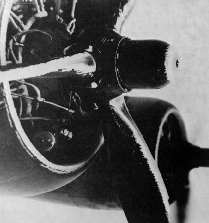
Figure 92. Propeller icing. Ice may form on propellers just as on any airfoil. It reduces propeller efficiency and may induce severe vibrations.
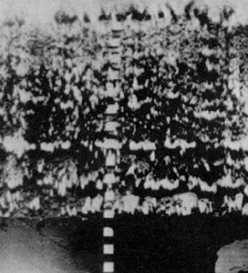
Rime ice forms when drops are small, such as those in stratified clouds or light drizzle. The liquid portion remaining after initial impact freezes rapidly before the drop has time to spread over the aircraft surface. The small frozen droplets trap air between them giving the ice a white appearance as shown at the center of figure 90. Figure 93 is a photograph of rime.
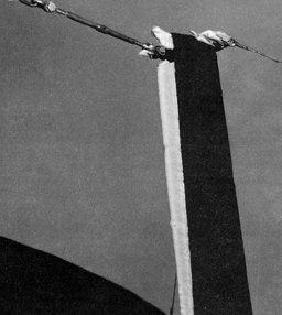
MIXED CLEAR AND RIME ICING Mixed ice forms when drops vary in size or when liquid drops are intermingled with snow or ice particles. It can form rapidly. Ice particles become imbedded in clear ice, building a very rough accumulation sometimes in a mushroom shape on leading edges as shown at the bottom of figure 90. Figure 94 is a photo of mixed icing built up on a pitot tube.
By mutual agreement and for standardization the FAA, National Weather Service, the military aviation weather services, and aircraft operating organizations have classified aircraft structural icing into intensity categories. Section 16 {Should be Section 14 - Ed.} of AVIATION WEATHER SERVICES (AC 00-45) has a table listing these intensities. The table is your guide in estimating how ice of a specific intensity will affect your aircraft. Use the table also in reporting ice when you encounter it.
The condition most favorable for very hazardous icing is the presence of many large, supercooled water drops. Conversely, an equal or lesser number of small droplets favors a slower rate of icing. Small water droplets occur most often in fog and low level clouds. Drizzle or very light rain is evidence of the presence of small drops in such clouds; but in many cases there is no precipitation at all. The most common type of icing found in lower level stratus clouds is rime. On the other hand, thick extensive stratified clouds that produce continuous rain such as altostratus and nimbostratus usually have an abundance of liquid water because of the relatively larger drop size and number. Such cloud systems in winter may cover thousands of square miles and present very serious icing conditions for protracted flights. Particularly in thick stratified clouds, concentrations of liquid water normally are greater with warmer temperatures. Thus, heaviest icing usually will be found at or slightly above the freezing level where temperature is never more than a few degrees below freezing. In layer type clouds, continuous icing conditions are rarely found to be more than 5,000 feet above the freezing level, and usually are two or three thousand feet thick. The upward currents in cumuliform clouds are favorable for the formation and support of many large water drops. The size of raindrops and rainfall intensity normally experienced from showers and thunderstorms confirm this. When an aircraft enters the heavy water concentrations found in cumuliform clouds, the large drops break and spread rapidly over the leading edge of the airfoil forming a film of water . If temperatures are freezing or colder, the water freezes quickly to form a solid sheet of clear ice. Pilots usually avoid cumuliform clouds when possible. Consequently, icing reports from such clouds are rare and do not indicate the frequency with which it can occur. The updrafts in cumuliform clouds carry large amounts of liquid water far above the freezing level. On rare occasions icing has been encountered in thunderstorm clouds at altitudes of 30,000 to 40,000 feet where the free air temperature was colder than minus 40° C. While an upper limit of critical icing potential cannot be specified in cumuliform clouds, the cellular distribution of such clouds usually limits the horizontal extent of icing conditions. An exception, of course, may be found in a protracted flight through a broad zone of thunderstorms or heavy showers.
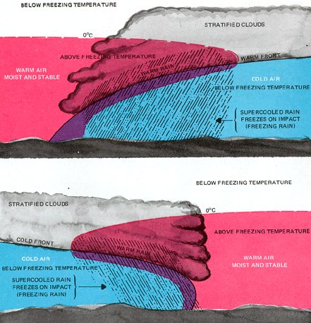
FRONTS A condition favorable for rapid accumulation of clear icing is freezing rain below a frontal surface. Rain forms above the frontal surface at temperatures warmer than freezing. Subsequently, it falls through air at temperatures below freezing and becomes supercooled. The supercooled drops freeze on impact with an aircraft surface. Figure 98 diagrams this type of icing. It may occur with either a warm front (top) or a cold front. The icing can be critical because of the large amount of supercooled water. Icing can also become serious in cumulonimbus clouds along a surface cold front, along a squall line, or embedded in the cloud shield of a warm front.
Air blowing upslope is cooled adiabatically. When the air is cooled below the freezing point, the water becomes supercooled. In stable air blowing up a gradual slope, the cloud drops generally remain comparatively small since larger drops fall out as rain. Ice accumulation is rather slow and you should have ample time to get out of it before the accumulation becomes extremely dangerous. When air is unstable, convective clouds develop a more serious hazard as described in "Icing and Cloud Types." Icing is more probable and more hazardous in mountainous regions than over other terrain. Mountain ranges cause rapid upward air motions on the windward side, and these vertical currents support large water drops. The movement of a frontal system across a mountain range often combines the normal frontal lift with the upslope effect of the mountains to create extremely hazardous icing zones. Each mountainous region has preferred areas of icing depending upon the orientation of mountain ranges to the wind flow. The most dangerous icing takes place above the crests and to the windward side of the ridges. This zone usually extends about 5,000 feet above the tops of the mountains; but when clouds are cumuliform, the zone may extend much higher. SEASONS Icing may occur during any season of the year; but in temperate climates such as cover most of the contiguous United States, icing is more frequent in winter. The freezing level is nearer the ground in winter than in summer leaving a smaller low level layer of airspace free of icing conditions. Cyclonic storms also are more frequent in winter, and the resulting cloud systems are more extensive. Polar regions have the most dangerous icing conditions in spring and fall. During the winter the air is normally too cold in the polar regions to contain heavy concentrations of moisture necessary for icing, and most cloud systems are stratiform and are composed of ice crystals.
Frost formation in flight offers a more complicated problem. The extent to which it will form is still a matter of conjecture. At most, it is comparatively rare.
Here are a few specific points to remember: 1. Before takeoff, check weather for possible icing areas along your planned route. Check for pilot reports, and if possible talk to other pilots who have flown along your proposed route. The man on the ground has no way of observing actual icing conditions. His only confirmation of the existence or absence of icing comes from pilots. Help your fellow pilot and the weather service by sending pilot reports when you encounter icing or when icing is forecast but none encountered. Use the table in Section 16 {Should be Section 14 - Ed.} of AVIATION WEATHER SERVICES as a guide in reporting intensities.
|