|
For Pilots and Flight Operations Personnel
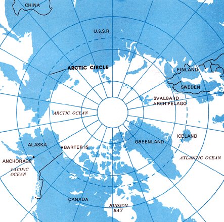
The Arctic, strictly speaking, is the region shown in figure 131 which lies north of the Arctic Circle (66 1/2° latitude). However, this chapter includes Alaskan weather even though much of Alaska lies south of the Arctic Circle.
Your most valuable source of information concerning flying the Arctic is the experienced Arctic flyer. To introduce you to Arctic flying weather, this chapter surveys climate, air masses, and fronts of the Arctic; introduces you to some Arctic weather peculiarities; discusses weather hazards in the Arctic; and comments on Arctic flying.
LONG DAYS AND NIGHTS A profound seasonal change in length of day and night occurs in the Arctic because of the Earth's tilt and its revolution around the sun. Figure 132 shows that any point north of the Arctic Circle has autumn and winter days when the sun stays all day below the horizon and days in spring and summer with 24 hours of sunshine. The number of these days increases toward the North Pole; there the sun stays below the horizon for 6 months and shines continuously during the other 6 months.
Figure 131 shows the water and land distribution in the Arctic. Arctic mountain ranges are effective barriers to air movement. Large masses of air stagnate over the inland continental areas. Thus, the Arctic continental areas are air mass source regions. A large portion of the Arctic Ocean is covered throughout the year by a deep layer of ice - the permanent ice pack as shown in figure 133. Even though the ocean is ice covered through much of the year, the ice and the water below contain more heat than the surrounding cold land, thus moderating the climate to some extent. Oceanic and coastal areas have a milder climate during winter than would be expected and a cool climate in summer. As opposed to large water bodies, large land areas show a more significant seasonal temperature variation.
As one would expect, the Arctic is very cold in winter; but due to local terrain and the movement of pressure systems, occasionally some areas are surprisingly warm. During winter, coastal areas average about 20° warmer than the interior. During summer, interior areas are pleasantly warm with many hours of sunshine. Coastal areas have relatively cool short summers due to their proximity to water. Cloudiness over the Arctic is at a minimum during winter reaching a maximum in summer and fall, figure 134. Spring also brings many cloudy days. During summer afternoons, scattered cumulus clouds forming over the interior occasionally grow into thundershowers. These thundershowers, usually circumnavigable, move generally from northeast to southwest in the polar easterlies which is opposite the general movement in mid-latitudes.
Strong winds occur more often along the coasts than elsewhere. The frequency of high winds in coastal areas is greatest in fall and winter. Wind speeds are generally light in the continental interior during the entire year, but are normally at their strongest during summer and fall. AIR MASSES - WINTER In winter, air masses form over the expanded ice pack and adjoining snow covered land areas. These air masses are characterized by very cold surface air, very low humidity, and strong low level temperature inversions. Occasionally, air from unfrozen ocean areas flows northward over the Arctic. These intrusions of moist, cold air account for most of the infrequent wintertime cloudiness and precipitation in the Arctic. AIR MASSES - SUMMER During the summer, the top layer of the Arctic permafrost layer melts leaving very moist ground, and the open water areas of the Polar Basin increase markedly. Thus, the entire area becomes more humid, relatively mild, and semi-maritime in character. The largest amount of cloudiness and precipitation occurs inland during the summer months. FRONTS Occluded fronts are the rule. Weather conditions with occluded fronts are much the same in the Arctic as elsewhere - low clouds, precipitation, poor visibility, and sudden fog formation. Fronts are much more frequent over coastal areas than over the interior.
EFFECTS OF TEMPERATURE INVERSION The intense low level inversion over the Arctic during much of the winter causes sound - including people's voices - to carry over extremely long distances. Light rays are bent as they pass at low angles through the inversion. This bending creates an effect known as looming - a form of mirage that causes objects beyond the horizon to appear above the horizon. Mirages distorting the shape of the sun, moon, and other objects are common with these low level inversions. AURORA BOREALIS In theory, certain energy particles from the sun strike the Earth's magnetic field and are carried along the lines of force where they tend to lower and converge near the geomagnetic poles. The energy particles then pass through rarefied gases of the outer atmosphere, illuminating them in much the same way as an electrical charge illuminates neon gas in neon signs. The Aurora Borealis takes place at high altitudes above the Earth's surface and thus has been observed as far south as Florida. However, the highest frequency of observations is over the northern United States and northward. Displays of aurora vary from a faint glow to an illumination of the Earth's surface equal to a full moon. They frequently change shape and form and are also called dancing lights or northern lights. LIGHT REFLECTION BY SNOW COVERED SURFACES Much more light is reflected by snow covered surfaces than by darker surfaces. Snow often reflects Arctic sunlight sufficiently to blot out shadows, thus markedly decreasing the contrast between objects. Dark distant mountains may be easily recognized, but a crevasse normally directly in view may be undetected due to lack of contrasts. LIGHT FROM CELESTIAL BODIES Illumination from the moon and stars is much more intense in the Arctic than in lower latitudes. Pilots have found that light from a half-moon over a snow covered field may be sufficient for landing. Even illumination from the stars creates visibility far beyond that found elsewhere. Only under heavy overcast skies does the night darkness in the Arctic begin to approach the degree of darkness in lower latitudes.
FOG Fog limits landing and takeoff in the Arctic more than any other visibility restriction. Water droplet fog is the main hazard to aircraft operations in coastal areas during the summer. Ice fog is the major restriction in winter. Ice Fog Ice fog is common in the Arctic. It forms in moist air during extremely cold, calm conditions in winter, occurring often and tending to persist. Effective visibility is reduced much more in ice fog when one is looking toward the sun. Ice fog may be produced both naturally and artificially. Ice fog affecting aviation operations most frequently is produced by the combustion of aircraft fuel in cold air. When the wind is very light and the temperature is about -30° F or colder, ice fog often forms instantaneously in the exhaust gases of automobiles and aircraft. It lasts from as little as a few minutes to days. Steam Fog Steam fog, often called "sea smoke," forms in winter when cold, dry air passes from land areas over comparatively warm ocean waters. Moisture evaporates rapidly from the water surface; but since the cold air can hold only a small amount of water vapor, condensation takes place just above the surface of the water and appears as "steam" rising from the ocean. This fog is composed entirely of water droplets that often freeze quickly and fall back into the water as ice particles. Low level turbulence can occur and icing can become hazardous. Advection Fog Advection fog, which may be composed either of water droplets or of ice crystals, is most common in winter and is often persistent. Advection fog forms along coastal areas when comparatively warm, moist, oceanic air moves over cold land. If the land areas are hilly or mountainous, lifting of the air results in a combination of low stratus and fog. The stratus and fog quickly diminish inland. Lee sides of islands and mountains usually are free of advection fog because of drying due to compressional heating as the air descends downslope. Icing in advection fog is in the form of rime and may become quite severe. BLOWING SNOW Over the frozen Arctic Ocean and along the coastal areas, blowing snow and strong winds are common hazards during autumn and winter. Blowing snow is a greater hazard to flying operations in the Arctic than in mid-latitudes because the snow is "dry" and fine and can be picked up easily by light winds. Winds in excess of 8 knots may raise the snow several feet off the ground obliterating objects such as runway markers as illustrated in figure 135. A sudden increase in surface wind may cause an unlimited visibility to drop to near zero in a few minutes. This sudden loss of visibility occurs frequently without warning in the Arctic. Stronger winds sometimes lift blowing snow to heights above 1,000 feet and produce drifts over 30 feet deep.
Icing is most likely in spring and fall, but is also encountered in winter. During spring and fall, icing may extend to upper levels along frontal zones. While icing is mostly a problem over water and coastal areas, it does exist inland. It occurs typically as rime, but a combination of clear and rime is not unusual in coastal mountains. FROST In coastal areas during spring, fall, and winter, heavy frost and rime may form on aircraft parked outside, especially when fog or ice fog is present. This frost should be removed; it reduces lift and is especially hazardous if surrounding terrain requires a rapid rate of climb. WHITEOUT "Whiteout" is a visibility restricting phenomenon that occurs in the Arctic when a layer of cloudiness of uniform thickness overlies a snow or ice covered surface. Parallel rays of the sun are broken up and diffused when passing through the cloud layer so that they strike the snow surface from many angles. The diffused light than reflects back and forth countless times between the snow and the cloud eliminating all shadows. The result is a loss of depth perception. Buildings, people, and dark colored objects appear to float in the air, and the horizon disappears. Low level flight over icecap terrain or landing on snow surfaces becomes dangerous. Disastrous accidents have occurred as a result of whiteouts.
Whiteouts, in conjunction with overcast skies, often present a serious hazard especially for visual flight. Many mountain peaks are treeless and rounded rather than ragged, making them unusually difficult to distinguish under poor visibility conditions. OCEANIC AND COASTAL AREAS In oceanic and coastal areas, predominant hazards change with the seasons. In summer, the main hazard is fog in coastal areas. In winter, ice fog is the major restriction to aircraft operation. Blowing and drifting snow often restrict visibility also. Storms and well defined frontal passages frequent the coastal areas accompanied by turbulence, especially in the coastal mountains. Icing is most frequent in spring and fall and may extend to high levels in active, turbulent frontal zones. Fog is also a source of icing when temperature is colder than freezing. CONTINENTAL AREAS Over the continental interior, good flying weather prevails much of the year; although during winter, ice fog often restricts aircraft operations. In terms of ceiling and visibility, the summer months provide the best flying weather. However, the number of cloudy days during the summer exceeds those in winter. Thunderstorms develop on occasion during the summer, but they usually can be circumnavigated without much interference with flight plans.
1. Interior areas generally have good flying weather, but coastal areas and Arctic slopes often are plagued by low ceiling, poor visibility, and icing.
|