|
For Pilots and Flight Operations Personnel
Technically, the Tropics lie between latitudes 23 1/2° N and 23 1/2° S. However, weather typical of this region sometimes extends as much as 45° ; from the Equator. One may think of the Tropics as uniformly rainy, warm, and humid. The facts are, however, that the Tropics contain both the wettest and driest regions of the world. This chapter describes the circulation basic to the Tropics, terrain influences that determine arid and wet regions, and transitory systems that invade or disturb the basic tropical circulation.
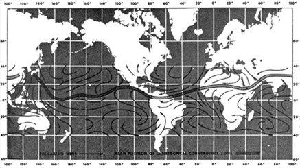
SUBTROPICAL HIGH PRESSURE BELTS If the surface under the subtropical high pressure belts were all water of uniform temperature, the high pressure belts would be continuous highs around the globe. The belts would be areas of descending or subsiding air and would be characterized by strong temperature inversions and very little precipitation. However, land surfaces at the latitudes of the high pressure belts are generally warmer throughout the year than are water surfaces. Thus, the high pressure belts are broken into semi-permanent high pressure anticyclones over oceans with troughs or lows over continents as shown in figures 23 and 24, chapter 4. The subtropical highs shift southward during the Northern Hemisphere winter and northward during summer. The seasonal shift, the height and strength of the inversion, and terrain features determine weather in the subtropical high pressure belts. Continental Weather Along the west coasts of continents under a subtropical high, the air is stable. The inversion is strongest and lowest where the east side of an anticyclone overlies the west side of a continent. Moisture is trapped under the inversion; fog and low stratus occur frequently. However, precipitation is rare since the moist layer is shallow and the air is stable. Heavily populated areas also add contaminants to the air which, when trapped under the inversion, create an air pollution problem. The extreme southwestern United States, for example, is dominated in summer by a subtropical high. We are all familiar with the semi-arid summer climate of southern California. Rainfall is infrequent but fog is common along the coast. Contaminants trapped along with fog under the strong inversion may persist for days creating "smog." In winter, the subtropical high pressure belts shift southward. Again, let's consider southern California as an example. In winter, the area comes under the influence of mid-latitude circulation which increases frequency of rain. Also, an occasional wintertime outbreak of polar air brings clear skies with excellent visibility. The situation on eastern continental coasts is just the opposite. The inversion is weakest and highest where the west side of an anticyclone overlies the eastern coast of a continent. Convection can penetrate the inversion, and showers and thunderstorms often develop. Precipitation is generally sufficient to support considerable vegetation. For example, in the United States, Atlantic coastal areas at the same latitude as southern California are far from arid in summer. Low ceiling and fog often prevent landing at a west coast destination, but a suitable alternate generally is available a few miles inland. Alternate selection may be more critical for an eastern coast destination because of widespread instability and associated hazards. Under a subtropical high over the open sea, cloudiness is scant. The few clouds that do develop have tops from 3,000 to 6,000 feet depending on height of the inversion. Ceiling and visibility are generally quite ample for VFR flight. Island Weather An island under a subtropical high receives very little rainfall because of the persistent temperature inversion. Surface heating over some larger islands causes light convective showers. Cloud tops are only slightly higher than over open water. Temperatures are mild, showing small seasonal and diurnal changes. A good example is the pleasant, balmy climate of Bermuda. TRADE WIND BELTS Figures 138 and 139 show prevailing winds throughout the Tropics for July and January. Note that trade winds blowing out of the subtropical highs over ocean areas are predominantly northeasterly in the Northern Hemisphere and southeasterly in the Southern Hemisphere. The inversion from the subtropical highs is carried into the trade winds and is known as the "trade wind inversion." As in a subtropical high, the inversion is strongest where the trades blow away from the west coast of a continent and weakest where they blow onto an eastern continental shore. Daily variations from these prevailing directions are small except during tropical storms. As a result, weather at any specific location in a trade wind belt varies little from day to day.
In the trade wind belt, skies over open water are about one-half covered by clouds on the average. Tops range from 3,000 to 8,000 feet depending on height of the inversion. Showers, although more common than under a subtropical high, are still light with comparatively little rainfall. Flying weather generally is quite good. Continental Weather Where trade winds blow offshore along the west coasts of continents, skies are generally clear and the area is quite arid. The Baja Peninsula of Lower California is a well known example. Where trade winds blow on shore on the east sides of continents, rainfall is generally abundant in showers and occasional thunderstorms. The east coast of Mexico is a good example. Rainfall may be carried a considerable distance inland where the winds are not blocked by a mountain barrier. Inland areas blocked by a mountain barrier are deserts; examples are the Sahara Desert and the arid regions of southwestern United States. Afternoon convective currents are common over arid regions due to strong surface heating. Cumulus and cumulonimbus clouds can develop, but cloud bases are high and rainfall is scant because of the low moisture content. Flying weather along eastern coasts and mountains is subject to the usual hazards of showers and thunderstorms. Flying over arid regions is good most of the time but can be turbulent in afternoon convective currents; be especially aware of dust devils. Blowing sand or dust sometimes restricts visibility. Island Weather Mountainous islands have the most dramatic effect on trade wind weather. Since trade winds are consistently from approximately the same direction, they always strike the same side of the island; this side is the windward side. The opposite side is the leeward side. Winds blowing up the windward side produce copious and frequent rainfall, although cloud tops rarely exceed 10,000 feet. Thunderstorms are rare. Downslope winds on the leeward slopes dry the air leaving relatively clear skies and much less rainfall. Many islands in the trade wind belt have lush vegetation and even rain forests on the windward side while the leeward is semiarid. For example, the island of Oahu, Hawaii, is about 24 miles wide in the direction of the trade winds. Annual rainfall averages from about 60 inches on the windward coast to 200 inches at the mountain tops, decreasing to 10 inches on the leeward shore. The greatest flying hazard near these islands is obscured mountain tops. Ceiling and visibility occasionally restrict VFR flight on the windward side in showers. IFR weather is virtually nonexistent on leeward slopes. Islands without mountains have little effect on cloudiness and rainfall. Afternoon surface heating increases convective cloudiness slightly, but shower activity is light. However, any island in either the subtropical high pressure belt or trade wind belt enhances cumulus development even though tops do not reach great heights. Therefore, a cumulus top higher than the average tops of surrounding cumulus usually marks the approximate location of an island. If it becomes necessary to "ditch" in the ocean, look for a tall cumulus. If you see one, head for it. It probably marks a land surface, increasing your chances of survival. THE INTERTROPICAL CONVERGENCE ZONE (ITCZ) Converging winds in the intertropical convergence zone (ITCZ) force air upward. The inversion typical of the subtropical high and trade wind belts disappears. Figures 138 and 139 show the ITCZ and its seasonal shift. The ITCZ is well marked over tropical oceans but is weak and ill defined over large continental areas. Weather over Islands and Open Water Convection in the ITCZ carries huge quantities of moisture to great heights. Showers and thunderstorms frequent the ITCZ and tops to 40,000 feet or higher are common as shown in figure 137. Precipitation is copious. Since convection dominates the ITCZ, there is little difference in weather over islands and open sea under the ITCZ.
Since the ITCZ is ill defined over continents, we will not attempt to describe ITCZ continental weather as such. Continental weather ranges from arid to rain forests and is more closely related to the monsoon than to the ITCZ. MONSOON If you refer again to figures 23 and 24 in chapter 4, you can see that over the large land mass of Asia, the subtropical high pressure breaks down completely. Asia is covered by an intense high during the winter and a well developed low during the summer. You can also see the same over Australia and central Africa, although the seasons are reversed in the Southern Hemisphere. The cold, high pressures in winter cause wind to blow from the deep interior outward and offshore. In summer, wind direction reverses and warm moist air is carried far inland into the low pressure area. This large scale seasonal wind shift is the "monsoon." The most notable monsoon is that of southern and southeastern Asia. Summer or Wet Monsoon Weather During the summer, the low over central Asia draws warm, moist, unstable maritime air from the southwest over the continent. Strong surface heating coupled with rising of air flowing up the higher terrain produces extensive cloudiness, copious rain, and numerous thunderstorms. Rainfall at some stations in India exceeds 400 inches per year with highest amounts between June and October. The monsoon is so pronounced that it influences circulation many miles out over the ocean. Note in figure 138 that in summer, prevailing winds from the Equator to the south Asian coast are southerly and southeasterly; without the monsoon influence, these areas would be dominated by northeasterly trades. Islands within the monsoon influence receive frequent showers. Winter Monsoon Weather Note in figure 139 how the winter flow has reversed from that shown in figure 138. Cold, dry air from the high plateau deep in the interior warms adiabatically as it flows down the southern slopes of the Himalayan Mountains. Virtually no rain falls in the interior in the dry winter monsoon. As the dry air moves off shore over warmer water, it rapidly takes in more moisture, becomes warmer in low levels and therefore, unstable. Rain is frequent over offshore islands and even along coastal areas after the air has had a significant over water trajectory. The Philippine Islands are in an area of special interest. During the summer, they are definitely in southerly monsoon flow and are subjected to abundant rainfall. In the winter, wind over the Philippines is northeasterly - in the transition zone between the northeasterly trades and the monsoon flow. It is academic whether we call the phenomenon the trade winds or monsoon; in either case, it produces abundant rainfall. The Philippines have a year round humid, tropical climate. Other Monsoon Areas Australia in July (Southern Hemisphere winter) is an area of high pressure with predominantly off shore winds as shown in figure 138. Most of the continent is dry during the winter. In January, figure 139, winds are onshore into the continental low pressure. However, most of Australia is rimmed by mountains, coastal regions are wet where the onshore winds blow up the mountain slopes. The interior is arid where downslope winds are warmed and dried. Central Africa is known for its humid climate and jungles. Note in figures 138 and 139 that prevailing wind is onshore much of the year over these regions. Some regions are wet the year round; others have the seasonal monsoon shift and have a summer wet season and a winter dry season. Climate of Africa is so varied that only a detailed area-by-area study can explain the climate typical of each area. In the Amazon Valley of South America during the Southern Hemisphere winter (July), southeast trades, as shown in figure 138, penetrate deep into the valley bringing abundant rainfall which contributes to the jungle climate. In January, the ITCZ moves south of the valley as shown in figure 139. The northeast trades are caught up in the monsoon, cross the Equator, and also penetrate the Amazon Valley. The jungles of the Amazon result largely from monsoon winds. Flying Weather in Monsoons During the winter monsoon, excellent flying weather prevails over dry interior regions. Over water, one must pick his way around showers and thunderstorms. In the summer monsoon, VFR flight over land is often restricted by low ceilings and heavy rain. IFR flight must cope with the hazards of thunderstorms. Freezing level in the Tropics is quite high - 14,000 feet or higher - so icing is restricted to high levels.
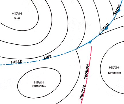
SHEAR LINE A wind shear line found in the Tropics mainly results from midlatitude influences. In chapter 8 we stated that an air mass becomes modified when it flows from its source region. By the time a cold air mass originating in high latitudes reaches the Tropics, temperature and moisture are virtually the same on both sides of the front. A shear line, or wind shift, is all that remains. A shear line also results when a semi-permanent high splits into two cells inducing a trough as shown in figure 140.
TROUGH ALOFT Troughs in the atmosphere, generally at or above 10,000 feet, move through the Tropics, especially along the poleward fringes. Figure 141 shows such a trough across the Hawaiian Island chain. As a trough moves to the southeast or east, it spreads middle and high cloudiness over extensive areas to the east of the trough line. Occasionally, a well developed trough will extend deep into the Tropics, and a closed low forms at the equatorial end of the trough. The low then may separate from the trough and move westward producing a large amount of cloudiness and precipitation. If this occurs in the vicinity of a strong subtropical jet stream, extensive and sometimes dense cirrus and some convective and clear air turbulence often develop.
TROPICAL WAVE Tropical waves (also called easterly waves) are common tropical weather disturbances, normally occurring in the trade wind belt. In the Northern Hemisphere, they usually develop in the southeastern perimeter of the subtropical high pressure systems. They travel from east to west around the southern fringes of these highs in the prevailing easterly circulation of the Tropics. Surface winds in advance of a wave are somewhat more northerly than the usual trade wind direction. As the wave approaches, as shown in figure 142, pressure falls; as it passes, surface wind shifts to the east-southeast or southeast. The typical wave is preceded by very good weather but followed by extensive cloudiness, as shown in figure 143, and often by rain and thunderstorms. The weather activity is roughly in a north-south line.
Tropical cyclone is a general term for any low that originates over tropical oceans. Tropical cyclones are classified according to their intensity based on average one-minute wind speeds. Wind gusts in these storms may be as much as 50 percent higher than the average one-minute wind speeds. Tropical cyclone international classifications are:
Strong tropical cyclones are known by different names in different regions of the world. A tropical cyclone in the Atlantic and eastern Pacific is a " hurricane"; in the western Pacific, "typhoon"; near Australia, "willy-willy"; and in the Indian Ocean, simply "cyclone." Regardless of the name, these tropical cyclones produce serious aviation hazards. Before we delve into these aspects, let's look at the development, movement, and decay of these cyclones. Development Prerequisite to tropical cyclone development are optimum sea surface temperature under weather systems that produce low level convergence and cyclonic wind shear. Favored breeding grounds are tropical (easterly) waves, troughs aloft, and areas of converging northeast and southeast trade winds along the intertropical convergence zone. The low level convergence associated with these systems, by itself, will not support development of a tropical cyclone. The system must also have horizontal outflow - divergence - at high tropospheric levels. This combination creates a "chimney," in which air is forced upward causing clouds and precipitation. Condensation releases large quantities of latent heat which raises the temperature of the system and accelerates the upward motion. The rise in temperature lowers the surface pressure which increases low level convergence. This draws more moisture laden air into the system. When these chain reaction events continue, a huge vortex is generated which may culminate in hurricane force winds. Figure 144 shows regions of the world where tropical cyclones frequently develop. Notice that they usually originate between latitudes 5° and 20°. Tropical cyclones are unlikely within 5° of the Equator because the Coriolis force is so small near the Equator that it will not turn the winds enough for them to flow around a low pressure area. Winds flow directly into an equatorial low and rapidly fill it.
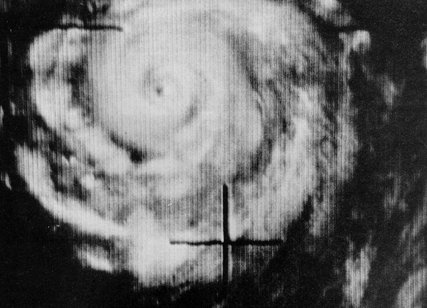
Tropical cyclones in the Northern Hemisphere usually move in a direction between west and northwest while in low latitudes. As these storms move toward the mid-latitudes, they come under the influence of the prevailing westerlies. At this time the storms are under the influence of two wind systems, i.e., the trade winds at low levels and prevailing westerlies aloft. Thus a storm may move very erratically and may even reverse course, or circle. Finally, the prevailing westerlies gain control and the storm recurves toward the north, then to the northeast, and finally to the east-northeast. By this time the storm is well into mid-latitudes. Decay As the storm curves toward the north or east, it usually begins to lose its tropical characteristics and acquires characteristics of lows in middle latitudes. Cooler air flowing into the storm gradually weakens it. If the storm tracks along a coast line or over the open sea, it gives up slowly, carrying its fury to areas far removed from the Tropics. However, if the storm moves well inland, it loses its moisture source and weakens from starvation and increased surface friction, usually after leaving a trail of destruction and flooding. When a storm takes on middle latitude characteristics, it is said to be " extra-tropical" meaning "outside the Tropics." Tropical cyclones produce weather conditions that differ somewhat from those produced by their higher latitude cousins and invite our investigation. Weather in a Tropical Depression While in its initial developing stage, the cyclone is characterized by a circular area of broken to overcast clouds in multiple layers. Embedded in these clouds are numerous showers and thunderstorms. Rain shower and thunderstorm coverage varies from scattered to almost solid. Diameter of the cloud pattern varies from less than 100 miles in small systems to well over 200 miles in large ones. Weather in Tropical Storms and Hurricanes As cyclonic flow increases, the thunderstorms and rain showers form into broken or solid lines paralleling the wind flow that is spiraling into the center of the storm. These lines are the spiral rain bands frequently seen on radar. These rain bands continually change as they rotate around the storm. Rainfall in the rain bands is very heavy, reducing ceiling and visibility to near zero. Winds are usually very strong and gusty and, consequently, generate violent turbulence. Between the rain bands, ceilings and visibilities are somewhat better, and turbulence generally is less intense. The "eye" usually forms in the tropical storm stage and continues through the hurricane stage. In the eye, skies are free of turbulent cloudiness, and wind is comparatively light. The average diameter of the eye is between 15 and 20 miles, but sometimes is as small as 7 miles and rarely is more than 30 miles in diameter. Surrounding the eye is a wall of cloud that may extend above 50,000 feet. This "wall cloud" contains deluging rain and the strongest winds of the storm. Maximum wind speeds of 175 knots have been recorded in some storms. Figure 145 is a radar display and 146, a satellite photograph of a mature hurricane. Note the spiral rain bands and the circular eye. Notice the similarity between these two figures.
The National Weather Service has a specialized hurricane forecast and warning service center at Miami, Florida, which maintains constant watch for the formation and development of tropical cyclones. Weather information from land stations, ships at sea, reconnaissance aircraft, long range radars, and weather satellites is fed into the center. The center forecasts the development, movement, and intensity of tropical cyclones. Forecast and warnings are issued to the public and aviation interests by field offices of the National Weather Service. Flying All pilots except those especially trained to explore tropical storms and hurricanes should AVOID THESE DANGEROUS STORMS. Occasionally, jet aircraft have been able to fly over small and less intense storms, but the experience of weather research aircraft shows hazards at all levels within them. Tops of thunderstorms associated with tropical cyclones frequently exceed 50,000 feet. Winds in a typical hurricane are strongest at low levels, decreasing with altitude. However, research aircraft have frequently encountered winds in excess of 100 knots at 18,000 feet. Aircraft at low levels are exposed to sustained, pounding turbulence due to the surface friction of the fast moving air. Turbulence increases in intensity in spiral rain bands and becomes most violent in the wall cloud surrounding the eye. An additional hazard encountered in hurricanes is erroneous altitude readings from pressure altimeters. These errors are caused by the large pressure difference between the periphery of the storm and its center. One research aircraft lost almost 2,000 feet true altitude traversing a storm while the pressure altimeter indicated a constant altitude of 5,000 feet. In short, tropical cyclones are very hazardous so avoid them! To bypass the storm in a minimum of time, fly to the right of the storm to take advantage of the tailwind. If you fly to the left of the storm, you will encounter strong headwinds which may exhaust your fuel supply before you reach a safe landing area.
|