|
For Pilots and Flight Operations Personnel PART I. WHAT YOU SHOULD KNOW ABOUT WEATHER
Imagine, if you can, how easy flying would be if skies everywhere were clear! But, flying isn't always that easy; moisture in the atmosphere creates a variety of hazards unmatched by any other weather element. Within Earth's climatic range, water is in the frozen, liquid, and gaseous states.
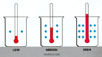
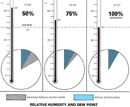
Relative humidity routinely is expressed in percent. As the term suggests, relative humidity is "relative." It relates the actual water vapor present to that which could be present. Temperature largely determines the maximum amount of water vapor air can hold. As figure 32 shows, warm air can hold more water vapor than cool air. Figure 33 relates water vapor, temperature, and relative humidity. Actually, relative humidity expresses the degree of saturation. Air with 100% relative humidity is saturated; less than 100% is unsaturated.
Figure 33. Relative humidity depends on both temperature and water vapor. In this figure, water vapor is constant but temperature varies. On the left, relative humidity is 50%; the warmer air could hold twice as much water vapor as is actually present. As the air cools, center and right, relative humidity increases. As the air cools to 37°F, its capacity to hold water vapor is reduced to the amount actually present. Relative humidity is 100% and the air is now "saturated." Note that at 100% humidity, temperature and dew point are the same. The air cooled to saturation, i.e., it cooled to the dew point.
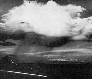
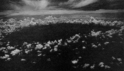
DEW POINT Dew point is the temperature to which air must be cooled to become saturated by the water vapor already present in the air. Aviation weather reports normally include the air temperature and dew point temperature. Dew point when related to air temperature reveals qualitatively how close the air is to saturation. TEMPERATURE - DEW POINT SPREAD The difference between air temperature and dew point temperature is popularly called the "spread." As spread becomes less, relative humidity increases, and it is 100% when temperature and dew point are the same. Surface temperature - dew point spread is important in anticipating fog but has little bearing on precipitation. To support precipitation, air must be saturated through thick layers aloft. Sometimes the spread at ground level may be quite large, yet at higher altitudes the air is saturated and clouds form. Some rain may reach the ground or it may evaporate as it falls into the drier air. Figure 34 is a photograph of "virga" - streamers of precipitation trailing beneath clouds but evaporating before reaching the ground. Our never ending weather cycle involves a continual reversible change of water from one state to another. Let's take a closer look at change of state.
CHANGE OF STATE
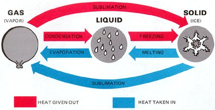
Any change of state involves a heat transaction with no change in temperature. Figure 35 diagrams the heat exchanges between the different states. Evaporation requires heat energy that comes from the nearest available heat source. This heat energy is known as the "latent heat of vaporization," and its removal cools the source it comes from. An example is the cooling of your body by evaporation of perspiration.
As air becomes saturated, water vapor begins to condense on the nearest available surface. What surfaces are in the atmosphere on which water vapor may condense? CONDENSATION NUCLEI The atmosphere is never completely clean; an abundance of microscopic solid particles suspended in the air are condensation surfaces. These particles, such as salt, dust, and combustion byproducts are "condensation nuclei." Some condensation nuclei have an affinity for water and can induce condensation or sublimation even when air is almost but not completely saturated. As water vapor condenses or sublimates on condensation nuclei, liquid or ice particles begin to grow. Whether the particles are liquid or ice does not depend entirely on temperature. Liquid water may be present at temperatures well below freezing. SUPERCOOLED WATER Freezing is complex and liquid water droplets often condense or persist at temperatures colder than 0° C. Water droplets colder than 0° C are supercooled. When they strike an exposed object, the impact induces freezing. Impact freezing of supercooled water can result in aircraft icing. Supercooled water drops very often are in abundance in clouds at temperatures between 0° C and -15° C with deceasing amounts at colder temperatures. Usually, at temperatures colder than -15° C, sublimation is prevalent; and clouds and fog may be mostly ice crystals with a lesser amount of supercooled water. However, strong vertical currents may carry supercooled water to great heights where temperatures are much colder than -15° C. Supercooled water has been observed at temperatures colder than -40° C. DEW AND FROST During clear nights with little or no wind, vegetation, often cools by radiation to a temperature at or below the dew point of the adjacent air. Moisture then collects on the leaves just as it does on a pitcher of ice water in a warm room. Heavy dew often collects on grass and plants when none collects on pavements or large solid objects. These more massive objects absorb abundant heat during the day, lose it slowly during the night, and cool below the dew point only in rather extreme cases. Frost forms in much the same way as dew. The difference is that the dew point of surrounding air must be colder than freezing. Water vapor then sublimates directly as ice crystals or frost rather than condensing as dew. Sometimes dew forms and later freezes; however, frozen dew is easily distinguished from frost. Frozen dew is hard and transparent while frost is white and opaque. To now, we have said little about clouds. What brings about the condensation or sublimation that results in cloud formation?
COOLING PROCESSES Three basic processes may cool air to saturation. They are (1) air moving over a colder surface, (2) stagnant air overlying a cooling surface, and (3) expansional cooling in upward moving air. Expansional cooling is the major cause of cloud formation. Chapter 6, "Stable and Unstable Air," discusses expansional cooling in detail. CLOUDS AND FOG A cloud is a visible aggregate of minute water or ice particles suspended in air. If the cloud is on the ground, it is fog. When entire layers of air cool to saturation, fog or sheet-like clouds result. Saturation of a localized updraft produces a towering cloud. A cloud may be composed entirely of liquid water, of ice crystals, or a mixture of the two.
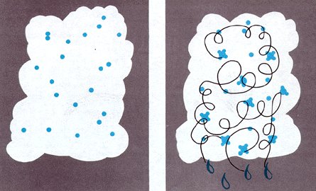
PARTICLE GROWTH Once a water droplet or ice crystal forms, it continues to grow by added condensation or sublimation directly onto the particle. This is the slower of the two methods and usually results in drizzle or very light rain or snow. Cloud particles collide and merge into a larger drop in the more rapid growth process. This process produces larger precipitation particles and does so more rapidly than the simple condensation growth process. Upward currents enhance the growth rate and also support larger drops as shown in figure 36. Precipitation formed by merging drops with mild upward currents can produce light to moderate rain and snow. Strong upward currents support the largest drops and build clouds to great heights. They can produce heavy rain, heavy snow, and hail.
Precipitation forming and remaining liquid falls as rain or drizzle. Sublimation forms snowflakes, and they reach the ground as snow if temperatures remain below freezing. Precipitation can change its state as the temperature of its environment changes. Falling snow may melt in warmer layers of air at lower altitudes to form rain. Rain falling through colder air may become supercooled, freezing on impact as freezing rain; or it may freeze during its descent, falling as ice pellets. Ice pellets always indicate freezing rain at higher altitude. Sometimes strong upward currents sustain large supercooled water drops until some freeze; subsequently, other drops freeze to them forming hailstones. PRECIPITATION VERSUS CLOUD THICKNESS To produce significant precipitation, clouds usually are 4,000 feet thick or more. The heavier the precipitation, the thicker the clouds are likely to be. When arriving at or departing from a terminal reporting precipitation of light or greater intensity, expect clouds to be more than 4,000 feet thick.
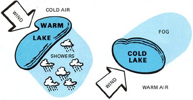
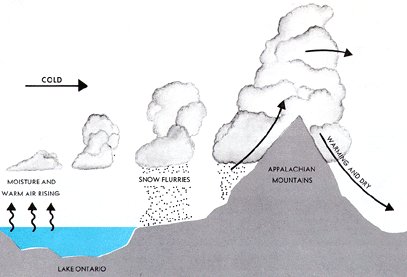
In winter, cold air frequently moves over relatively warm lakes. The warm water adds heat and water vapor to the air causing showers to the lee of the lakes. In other seasons, the air may be warmer than the lakes. When this occurs, the air may become saturated by evaporation from the water while also becoming cooler in the low levels by contact with the cool water. Fog often becomes extensive and dense to the lee of a lake. Figure 37 illustrates movement of air over both warm and cold lakes. Strong cold winds across the Great Lakes often carry precipitation to the Appalachians as shown in figure 38.
Figure 38. Strong cold winds across the Great Lake absorb water vapor and may carry showers as far eastward as the Appalachians.
1. Fog when temperature - dew point spread is 5° F or less and decreasing.
|